![New FAA Drone Map Shows Flying Restrictions Around Bangor](http://townsquare.media/site/543/files/2017/10/Drone.jpg?w=630&h=420&zc=1&s=0&a=t&q=89&w=980&q=75)
New FAA Drone Map Shows Flying Restrictions Around Bangor
Ever wondered exactly where and how high you're allowed to fly a drone in Bangor?
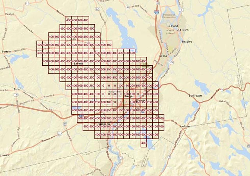
A new ONLINE MAP released by the Federal Aviation Administration shows that if you're planning on operating a UAS, or, Unmanned Aircraft System, in the Queen City, that the Bangor International Airport is certainly not the area to be doing it in.
The new FAA page shows you ceiling height and where exactly you cannot fly a drone. Looking at the map below you'll see that there are height restrictions anywhere from 0 feet, airspace where you cannot fly at all, to between 100 and 400 feet. Remember, if you're going to fly a drone anywhere, you should contact Bangor Tower BGR ATCT before doing so.
FAA.com image
More From WWMJ Ellsworth Maine
![3 Arrested In Theft Of ATM Inside Of “Tubby’s Ice Cream” In Wayne](http://townsquare.media/site/543/files/2024/07/attachment-RS23730_GettyImages-960131070-scr.jpg?w=980&q=75)
![Slow Your Roll, Spirit Halloween: We’re Not Done With Summer Just Yet!](http://townsquare.media/site/543/files/2024/07/attachment-Resized_20240726_131801_1722014294204.jpeg?w=980&q=75)
![Third Arrest Made In Connection To A Death In Cushing Earlier This Month](http://townsquare.media/site/494/files/2021/11/attachment-RS23905_GettyImages-466688316-scr.jpg?w=980&q=75)
![Are Maine’s Famous Red Snapper Hot Dogs Based on a British Sausage?](http://townsquare.media/site/543/files/2024/07/attachment-Red-Sav.jpg?w=980&q=75)
![Look at One of the Most Stunning and Unique Moths in New England](http://townsquare.media/site/543/files/2024/07/attachment-HM.jpg?w=980&q=75)